
Create a new Calculated Field as Geography dimension
6 January, 2015
Hi All,
I'm creating a map using the Australian GeoPack: the State codes used in our DW are different from the GeoPack (ex: our code is NSW, but in the GeoPack New SOuth Wales is 154 or AU.NS).
So I need to create a new field to map our code to the GeoPack codes, and then link the GeoPack to this new field:
NSW --> 154
QLD --> 156
VIC --> 160
etc
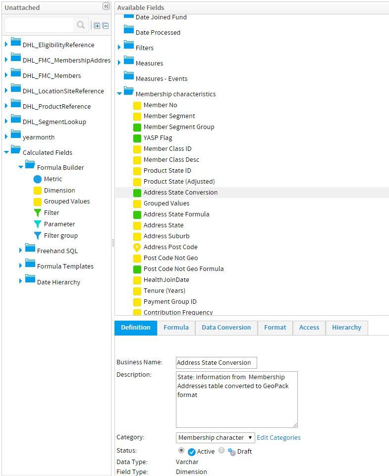
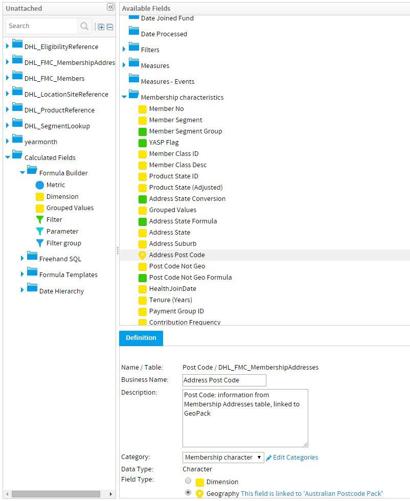
When I create a new calculated field as Dimension (with Formula Builder) I can't choose the geography option. The field is a Varchar, but I miss some options compared to a normal dimension:

Here the details of a dimension (field) from the DW, that's a Character, not a Varchar:
Any idea on how I can solve this issue, of any workaround I could do?
I would prefer to avoid to do the conversion in the DW.
Thanks
Francesca
I'm creating a map using the Australian GeoPack: the State codes used in our DW are different from the GeoPack (ex: our code is NSW, but in the GeoPack New SOuth Wales is 154 or AU.NS).
So I need to create a new field to map our code to the GeoPack codes, and then link the GeoPack to this new field:
NSW --> 154
QLD --> 156
VIC --> 160
etc
When I create a new calculated field as Dimension (with Formula Builder) I can't choose the geography option. The field is a Varchar, but I miss some options compared to a normal dimension:
Here the details of a dimension (field) from the DW, that's a Character, not a Varchar:
Any idea on how I can solve this issue, of any workaround I could do?
I would prefer to avoid to do the conversion in the DW.
Thanks
Francesca
Hi Francesca,
I believe this query is being handled by another partner.
Once you get this resolved, please post the results if you don't mind.
Thank you for your understanding.
Regards,
David
I believe this query is being handled by another partner.
Once you get this resolved, please post the results if you don't mind.
Thank you for your understanding.
Regards,
David
Hi David,
could you please confirm that the GeoPack could be used to design maps at all levels, not only the postcode level?
Thanks
Francesca
could you please confirm that the GeoPack could be used to design maps at all levels, not only the postcode level?
Thanks
Francesca
Hi David,
the Wiki secton on GeoPacks (http://wiki.yellowfin.com.au/display/USER71/GeoPacks) refers about a State code with 3 digits: are there many GeoPacks available for Australia?
Thanks,
Francesca
the Wiki secton on GeoPacks (http://wiki.yellowfin.com.au/display/USER71/GeoPacks) refers about a State code with 3 digits: are there many GeoPacks available for Australia?
Thanks,
Francesca
Hi Francesca,
At the moment we have 1 Australian (and New Zealand, if you count that also).
Australia Postcode Pack
This GeoPack provides geometry for states, local government areas (LGAs) and postcodes within Australia.
It includes census derived demographics for population by age, as well as various demographics for area income, labor force and unemployment. Please note that because LGA to postcode is not a standard hierarchy some LGAs do not have demographic associated with them. Also note that postcodes do not cover 100% of land areas.
Were you after this pack?
If so, you should be able to get it through Bill/Richard/George as they have login access to our site.
Please let me know if you have any other questions on this.
Regards,
David
Hi David,
thanks for the reply.
We already have the Australia Postcode Pack.
THe issue is the State Code used in the Australia Postcode Pack: in our data we use a State code like "VIC, NSW, etc", while the Geopack uses numeric codes as 154, 156,160.
THat's weird because the Wiki documentation refers to a State code with 3 letters, as the one we are using.
(here: http://wiki.yellowfin.com.au/display/USER71/GeoPacks)
So at the moment we cannot link our geographical data to the Geopack..
Cheers,
Francesca
Hello Francesca,
Very sorry for the delay in getting back to you, just wanted to touch base to see if you're still having issues linking your geodata to the YF Geopack?
If so, there are a number of videos uploaded to our YF YouTube Channel which deal with Geopacks and linking data, that might assist you.
Please let me know how you're getting on, and if I can help you further.
Kind Regards,
Danny
HI Danny,
yes, we are still having issues because we didn't have any reply yet.
We had already a look at the Youtube videos and at the documentation (we opened the thread one month ago...), and as I already wrote above few times, they are both unclear: could the support please reply to our question?
We found a workaround but it's not a clean solution because we are creating "dirty" data in the Data Warehouse just for Yellowfin visualisation.
THe issue is the State Code used in the Australia Postcode Pack: in our data we use a State code like "VIC, NSW, etc", while the Geopack uses numeric codes as 154, 156,160.
THat's weird because the Yellowfin Wiki documentation refers to a State code with 3 letters, as the one we are using. Here the link in the Wiki documentation, that it's quite different from the content in the Geopack: http://wiki.yellowfin.com.au/display/USER71/GeoPacks.
It would be great if you guys could open the Geopack and have a look at it, and figure out why the documentation is different from it.
Thanks,
Francesca
Hello Francesca,
Sincere apologies for the delay in getting back to you.
I have confirmed with our Development team that it appears that a standard 3-letter State Code wasn't added as a formatting option when linking fields to geodata, however I have created an Enhancement Task ( #187131 ) to have this added to a future update to the Aust. Postcode Geopack.
Does your workaround use Virtual Tables? If not, this may assist in reducing the amount of unnecessary data in your DW.
I will keep you updated here if there is any progress on the addition of the 3-letter State codes to the Geopack.
Kind Regards,
Danny